Tales from Days Gone By
New episode released the second and fourth Thursday of the month.
Behind the big themes, celebrated figures, and dry dates of history are the interesting stories of life in the past and ordinary people. Southeast Missouri has a varied and rich history that you often don’t hear about in history classes. Join Bill Eddleman of the State Historical Society of Missouri to hear about these stories with “Tales from Days Gone By.”
Latest Episodes
-
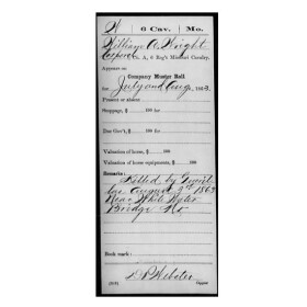 The story of one of the most notorious events occurring near Cape Girardeau during the Civil War began in St. Louis in the early summer of 1863.
 -
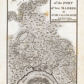 Two major European allies assisted the fight for American Independence: France and Spain. One of the consequences of the alliance with Spain was a more favorable view of Americans by the Spanish authorities in Louisiana.
 -
 July 27, 1871, proved to be a tragic day in the small Wayne County community of Lowndes.
 -
 The lure of riches has given rise to many historical events. Sometimes the promised boom happens, but often the lure leads to overly optimistic visions. One such event occurred in the late 1880s in Stoddard County.
 -
 Reflecting on the upcoming 250th Anniversary of the American Revolution, it seems unlikely that southeastern Missouri had any role. However, hostilities did directly affect those who lived in Ste. Genevieve.
 -
 One of the most influential of Wayne County’s public servants in the late 19th Century was a Russian immigrant who came to the U.S. with his father in 1849.
 -
 The period from May 25 through June 1, 1917, was one of the worst severe weather weeks in the history of southern Missouri. During that time, three low pressure systems in succession formed on the Plains and swept through the southern Midwest and upper South.
 -
 Perhaps no physician who practiced in southeast Missouri in the 19th century had as varied a career as Dr. Drake McDowell. Drake, or Isaac, McDowell was eldest son of Dr. Joseph Nash McDowell of St. Louis. He was born in Cincinnati in 1831 and came to St. Louis in 1840 with the family.
 -
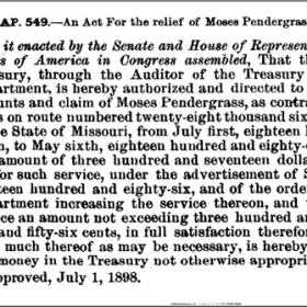
![A portion of the application for a post office for Punjaub/Lawrenceton, dated October 3, 1865. Punjaub is marked through and the notation, “ch[anged] na[me] to ‘Lawrenceton’ Apr. 9/77” added. Post Office Department Records of Site Locations, 1837-1955, National Archives and Records Administration, microfilm M1126, Roll 344, Missouri, St. Francois – St. Louis Counties, image 349.](https://npr.brightspotcdn.com/dims4/default/2c7e647/2147483647/strip/true/crop/337x337+84+0/resize/280x280!/quality/90/?url=http%3A%2F%2Fnpr-brightspot.s3.amazonaws.com%2F70%2F5a%2Fb13189db4fddbe31417274fddc86%2Fpunjaub.png) The present-day community of Lawrenceton is about 15 miles west of Ste. Genevieve. It is unincorporated, but in its heyday, it had a post office between 1867 and 1941. The initial town, Punjaub, officially changed to Lawrenceton in 1877. So how did an Ozark border community receive the name of a region in India, then later become Lawrenceton?
The present-day community of Lawrenceton is about 15 miles west of Ste. Genevieve. It is unincorporated, but in its heyday, it had a post office between 1867 and 1941. The initial town, Punjaub, officially changed to Lawrenceton in 1877. So how did an Ozark border community receive the name of a region in India, then later become Lawrenceton? -
 The wheels of justice operate in most cases—but often slowly. A tale from St. Francois County illustrates exactly how slowly.


![A portion of the application for a post office for Punjaub/Lawrenceton, dated October 3, 1865. Punjaub is marked through and the notation, “ch[anged] na[me] to ‘Lawrenceton’ Apr. 9/77” added. Post Office Department Records of Site Locations, 1837-1955, National Archives and Records Administration, microfilm M1126, Roll 344, Missouri, St. Francois – St. Louis Counties, image 349.](https://npr.brightspotcdn.com/dims4/default/ada56c3/2147483647/strip/true/crop/337x337+84+0/resize/560x560!/format/webp/quality/90/?url=http%3A%2F%2Fnpr-brightspot.s3.amazonaws.com%2F70%2F5a%2Fb13189db4fddbe31417274fddc86%2Fpunjaub.png)
